Thursday, December 23, 2010

Tashkent (from Bonn)


I spent three weeks at ZEF now, in Bonn, and, I have to say, both city and institute are quite inspiring environments. In Bonn, I was impressed with the architecture, the cultural life, but even more so the layout of the city, with green areas and snippets of agricultural land penetrating deep into the urban fabric, and with medieval villages incorporated without completely losing their identity. At ZEF, I was impressed with the rich texture of approaches and methods, their selective blending, and certainly by the intensity of debates, even after ten years of Khorezm research.

That helped me in thinking through the Uzbek experience. Not that I have final answers, but at least some storylines are crystallizing -again in discussion with colleagues at the institute. The role of knowledge in evolving land use governance, shifts in the organizational environment of the agricultural system -largely responsible for land governance- and a study of policy integration in the planning system are in the pipeline. In all these stories, questions regarding the actual role of Tashkent, of the center of power, return. Once again, no simple answers.

It looks like post-Soviet Uzbekistan is more centralized in the production of knowledge than in the application of power. The cliche image of an authoritarian pyramid, with everything revolving around the leader, does not appear suitable. Just as in Soviet times, there is flexibility, there are players at different places and levels. With regard to knowledge, it looks like Tashkent is becoming ever more important. Tashkent universities and institutes seem to have adapted better to changing scientific ideologies, they received more attention from the state, and the Tashkent network benefits more from international organizations, to a certain extent even from international competition (several foreign universities have franchises there) Moreover, the de- institutionalization of knowledge in the countryside seems much more extreme -old roles associated with a certain expertise have disappeared, or became disconnected from the expectation of expertise.

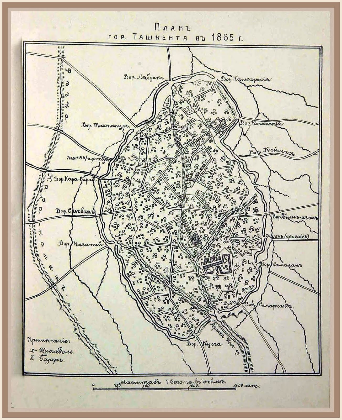
As to city design, there is, like in Bonn, a lot of green space, most of it Soviet-era park space. Some of those parks are draped around a web of litte natural streams that made the area attractive in the first place. The Uzbek government made a great effort to ´streamline´the city, to clarify and reinforce the Soviet neo- baroque structure of parks, boulevards and vista´s connecting public buildings (See the map) Parts of the old town, originally marked by a dense maze of little streets, have been integrated into that structure. This strategy, however rigorous, does encourage development, and also in this regard, Tashkent is the place where it happens. Whatever the flows of resources look like, they end up in Tashkent, more than in the past.

Friday, December 3, 2010

Tashkent (from Belgium)


Yes, it has been a while. I spent two weeks in Tashkent, trying to improve the framing of the Khorezm research by means of extra interviews. Time well spent, I believe. Rarely access to internet there, so few blogging opportunities. Monday night, I arrived in Belgium, tomorrow to Bonn, to ZEF, for two more months Uzbek research. More stories later.

But now, something about Tashkent. A different world it is, a slight shock after some months in Khorezm. No trace of doubt that this is where it happens; this is the center of power. A sustained building boom, continuous improvements in infrastructure, attention to urban design, mushrooming businesses, a cosmopolitan population, an influx of migrants from the provinces. And prices more common in European capitals.

Tashkent is a Russian creation, much more than other sizeable cities in Uzbekistan. A few buildings predate the Russian arrival -a 16th century medrese, religious school, being the most notable example- but most "old" buildings are pre- communist, in neoclassical or eclectic styles, sometimes close to Art Nouveau. The 1865 map above gives an indication of the starting point. Communist development, boosted by (forced) immgration of Russian, Greek, Armenian, Italian architects, produced a neatly ordered city of over three million. Post- independence planning usually follows the communist pattern, with a gradual enclosure and replacement however of the remaining traditional neighborhoods, the mahalla´s. Some of them will probably remain, since some major players prefer to live in the best of those neighborhoods, still marked by low single family homes, with green courtyards.

Despite the severing of connections with the dissolution of the USSR, Tashkent is still recognizable as the intended capital of Soviet Central Asia. That is, as the capital of something larger than the present country. (Just as Vienna still betrays its past as the center of something bigger) Also in research facilities, this is visible: the major institutes responsible for the Soviet development of Central Asia, for irrigation design, rural development, city planning, agricultural engineering are still there, be it in a considerably shrunken state. The institutional apparatus that guided Soviet development in its heydays, can not reasonably be sustained. Even in the later years of the USSR, after most reclaimable land was reclaimed and most usable water used, it was clear that not every institute was still necessary.

Nor was it affordable. The Soviets could not afford Central Asia anymore. One reason was the oversized research and development apparatus, a second one the inefficient agricultural economy that apparatus groomed. Both Soviets and the post- Soviet government tried to get rid of the system, with its overuse of water, land, its oversized workforce and its problematic adapation. Once more, experts in Tashkent, sometimes the same experts, in the shrunken institutions, have to rethink the use of land and water. The Uzbek government does realize the urgency, and foreign donors got the message as well.

Monday, November 15, 2010

Flexibility and design


Soviet architecture is always and everywhere the same. So it seems. In fact, cities like Kiev, Riga and Tbilisi (picture) have Soviet- era neighborhoods that are well- designed, pleasant, green, modernist but not monotonous. In other places, cookie- cutter developments scatter high- risers over gloomy landscapes.

Soviet republics were fighting over resources, all the time. Kiev usually got more than Tashkent. Sometimes, disparities were incorporated in the building codes and norms (SNIP), so the standards fo Siberian apartment were very different from one in the Baltics. Some places were allowed to buildr a more, but got relatively few resources, and the other way around. In some places, resources were used more efficiently than elsewhere.

Then there is the issue of monotony. Some cities, regions, republics, were not especially eager to deviate from the norms, or to improve the norms. As long as the development machine kept running, with some spoils here and there, things were ok. While other areas asserted their individuality, and wanted to adapt the standards to local conditions and tastes, to increase the importance of design. In this game, regions were not always pitted against each other or the center; rather, state organizations faced each other. Large construction firms, kombinats, were pushing for uniformity, easier for them. Some academics were stressing the importance of norms for ‘correct’ building. But other academics, planners, architects, in the regions and in Moscow, asserted that flexibility was important and not necessarily more expensive.

One of the architects we spoke, had a career spanning Kiev, Moscow, Tashkent, and Urgench, and told stories about lively discussions in the 70’s on this topic. He was arguing for flexibility, and found allies and foes in all places. In newspapers and architectural magazines, the discussion raged on. In practice, what recreated the more boring development patterns was not so much pressure from political actors, as habits and routines in a chain of organizations, and with users. Standards became important because they were easy. Sleek architects used scientific arguments to be creative: no, we cannot follow the standards, because of the local climate, the geology, the seismic situation. Science, a force behind standardization, was also a tool to force flexibility.

(My days in Urgench are coming to an end. Wednesday, to Tashkent. I heard they have coffee places.)

Wednesday, November 10, 2010

Fish in the desert


Today, I was in Ashirmat, my favorite village on the Turkmen border. Interesting interviews, but also a good, hearty lunch: fried carp with onions, vinegar and bread -eerily close to fish 'n chips.

My friend Erik- Jan, resident fisheries engineer in Norway, already indicated that we're probably dealing with grass carp, introduced to clean up the irrigation canals. And indeed, that is what the Uzbek colleagues confirmed, and what I found in an FAO study: introduced in 1958 for weed control, taking over most native species in the freshwater bodies (in Korezm, 36 species still hanging in there). People here acquired a taste for fish, and the collapse of Aral Sea fisheries meant more pressure on inland waters.

That's why currently every little swamp, each insignificant irrigation canal, minute pond or drainage lake (if not too salty) is used for fishing, for carp, and sometimes catfish -an omnivorous predator of the abundant carp. Even rice fields are used for fishing. I saw people pushing tiny boats through swamps with barely a stretch of open water, kids hauling up nets from ditches, and every now and then a man on a bridge, proudly showing a trophy carp.

For many villages in Khorezm, the lakes and wetlands, especially natural ones, are symbolic places; fishing there is an almost ritualized activity, more important than an extra acre of farmland. In the heyday of Soviet land reclamation, this local attachment was probably as effective a protection as their functionality as drainage reservoir.

And the grass carp? He was a bit too successful, cleaned up the weeds, but apparently didn't appreciate ranunculus species (like buttercups) so one group of weeds replaced another one. Luckily, the locals do appreciate the grass carp.

Sunday, November 7, 2010

Local knowledge


Talk about local knowledge mostly implies that local perspectives are somehow dismissed or ignored or simply not observed by decision- makers. High modernist states are assumed to be among the worst here, and the worst of the worst has to be the hyper- planned Soviet Union. That is the standard story, at least. The fact that the U.S.S.R. does not exist anymore, is seen as the proof of the pudding, and also makes sure that very few will come to its defense.

After spending some time in Uzbekistan, and reflecting on my experiences in a few other places, I tend to believe that over- planning was not the problem, and that local knowledge was everywhere. One of the difficulties, I think, was the enormous gap between formal and informal, the difference between the official self- descriptions and the actual functioning of the Soviet state.

That meant that in some places, and for some issues bottom- up initiatives were existing but not acknowledged, while in other cases, the opposite was true, and pseudo- local knowledge figured in fake participation. Kolkhoz workers could convince their chair of a better land use, and he could get it done. Local party leaders could jump directly to Moscow to plea their case. Local actors did their own thing, based on their insights, without even telling. Sometimes, this was simply a way to make the system work, sometimes a way for local players to enrich themselves.

Showing how things really worked was difficult because officially, all Soviet citizens were the same, wanted the same, and the State knew the needs of the collective. Showing how things worked would reveal the limits of central planning, it would reveal local differences and knowledges, and cliques thriving on black markets. But, it would also show where in fact more planning would be useful, where more coordination between interests (once acknowledged) could bring the common good closer.

(The house is empty now. In the summer, I had to wait in line for hours to take a shower, now I have three bathrooms for myself. One has hot water, so the choice is easy)

Wednesday, November 3, 2010

Sovkhoz and chicken


Today and yesterday, I got to visit two other places in the region, Shavat and Amir Timur.

In Shavat, we were hosted by a retired kolkhoz chief in a most sumptuous manner, with pomegranates and other fruits from his garden, sweets, vodka, salads, vodka, bread, vodka, and a rather intriguing chicken dish. The chicken is cut in pieces, browned in a pan, then quince, turnip, onions, coriander seed and garlic are added, and the whole slowly simmers. Our host quoted at length from the Avesta, the book of Zoroaster, who presumably lived in this area ca 1000 BC.

Once I got over my fascination with the chicken and Zarathustra, the conversation went well, and I learnt quite a few things about the relations between kolkhoz, collective farms, and sovkhoz, state farms. The two were much more interwoven than I thought, and some of the stories we heard before, made more sense.

A sovkhoz could be initiated by players at all levels: the military could order their establishment to provide food security for bases in the republics, industrial ministries could push for state farms producing inputs for manufacturing, regional and local leaders could lobby for farms in their areas. And kolkhoz managers could move the idea forwards. If the sovkhoz was dropped from high up, the chances for success were usually lower -people were less motivated to work, more motivated to secretly privatize some assets.

If local party leaders or kolkhoz people wanted them, then they usually were part of an economic development strategy that actually made sense for the locals. Sometimes a kolkhoz director wanted a sovkhoz next door in the hope to take over the state- financed enterprise later, to expand his own business, sometimes he thought it would be important for a next generation of farmers. Local party people were interested in employment opportunities, in infrastructural investment, in synergies with other assets and activities.

These Soviet bottom- up development strategies, I believe, are not so different from what you can find in the U.S. right now: local communities have to lobby continuously with higher levels of government and with businesses for investment, to cover even the most basic needs. In the U.S.S.R., competition was as fierce as anywhere else, it is just that all players were officially under the label 'state'.

Saturday, October 30, 2010

Rais


A rais is a kolkhoz director. The kolkhoz, the Soviet collective farm, does not exist anymore, but the rais is still prevalent in the collective imagination. Arguably, it is the most important public figure that has disappeared with the Soviet Union.

A kolkhoz could be home to 500 people, but also 20.000. For all practical purposes, the kolkhoz leadership was local government. Leadership styles could vary, from quite democratic -listening to the farmers- to quite undemocratic -focussing on the Party, on self- interest. With the gradual privatization of land came the dissolution of the kolkhoz, a fragmentation of ownership and decision- making, a scattering of responsibilities over a host of successor- organizations.


The tasks of the collective farm, supervised by the rais, were distributed over water user associations, machine tractor parks, district architects and surveyors, and mahalla chiefs (leading formalized neighborhood associations). Most of the real decision- making power moved to the district hakims, the political/ administrative leaders. At the village level, a role remained for the rural chairman, in name almost a new rais, in practice a low- level legal servant.

In the last few weeks, we were finally able to meet a fair number of ex- rais. Very helpful. Some of them climbed the ladder in one kolkhoz, others moved around a bit, in different positions in the agro- system, others were specifically appointed for having no local connections at all -like the podesta in Italian city- states. Most of them had an agricultural engineering background. Degrees in law, economic or politics were non-existing or irrelevant for these future super- mayors. The official image of the kolkhoz was that of a production machine; its functions as local government were secondary. Not only land-use, also the community itself was considered mono- functional.


Talking about land use and planning, it struck me once more how virtually everything was presented as planned, sanctioned and approved by others, by the State, by a long list of other organizations. At the same time, decisions were presented as purely democratic, emerging from the ranks of the workers, the families taking care of a few hectares each. That many, if not most, ideas relating to planning and development came from the kolkhoz leadership, remains out of sight first, becomes apparent only after long conversations. Farm managers could decide on many things, if the budget was there and the cotton targets were not touched.

(Saturday, my first wedding party in Uzbekistan. In fact, it was a pre- wedding party, organized by the family of the bride, primarily for women, part of a long list of ritualized events spanning about a week. Excellent food and drinks, conducive to traditional Uzbek dance- I got some practice.)

Friday, October 29, 2010

Cotton research, cotton landscapes


In the last few days, we talked to a number of people at the regional cotton research institute, just outside of town. More interesting than I thought.

A research station, like this one, was basically a kolkhoz + research institute. That meant that budgets were partly coming from the state (for research) and partly generated by the collective (the farm). Decisions on improvement, expansion, and other planning- related things were taken more or less like in a kolkhoz, with the director of the institute in a role similar to that of the rais, the kolkhoz leader. Like a kolkhoz, a research station could be very extensive, and could be seen as de facto local government.

In this case, the station at its peak covered over 600ha (making it smaller than an average kolkhoz) and included a village and a plethora of technical, scientific, and farm buildings. Its location was not perfect, close to a growing city and dotted with marshlands, ponds, lakes, and tugai floodplain forest, but a sustained reclamation campaign, lasting until the late 80's, turned it into a model farm. In the last decade, the cooperation with our research project, with ZEF/ Unesco has been intense. Only recently, outsiders were allowed to settle in the village, hard to avoid with Urgench so close.


When the Soviets came, they were serious about cotton, and already in 1922, right after arrival, they established a cotton research station in Khiva. It was moved to Urgench in 1929. New varieties had to be developed; the known ones preferred warmer and wetter regions, like the American South, the main rival in the eyes of the Soviets. At the Urgench site, different directors brought their own visions of the perfect cotton plant and the perfect cotton landscape to the model farm. Varieties like Khorezm 126, 127 and 150 were developed here, suited to the specificities of the region. Farmers were informed and advised.

We talked to an 88-year old gentleman, still busy with the development of ever more productive cotton varieties. In a slightly delapidated concrete building, housing, among other things, a library devoted to cotton, he showed us various cotton plants, and told a story of continuous pressure to improve, with different requirements taking precedence at different times. For the Soviets, productivity was everything, and nobody paid too much attention to the cost of inputs, of labor, land and water. With independence, the loss of Soviet subsidies, and the seeping in of market principles, accounting practices changed, and everything taken for granted, suddenly had a price tag. Efficiency and sustainability became real concerns.


That implied a reduction of 'agro- technical works', a catch- all for everything involving machinery. New cotton varieties are supposed to require less water, less fertilizer, less ditches and seasonal canals. The cotton landscape now is reportedly less messy, less fragmented, and more stable because of that. On the other hand, the countryside is more multifunctional now than in the past, with large cotton or wheat parcels and smaller vegetable plots alternating in many areas; moving rice fields and their levies change the topography almost yearly. In other words, the cotton landscape might be more stable, but many places are not cotton landscapes anymore.

Thursday, October 21, 2010

Farmers, knowledge and land


Yesterday, I was at a symposium on agricultural extension in Central Asia. Quite interesting.
Farmers need to know things to do their job, and keeping up with the latest innovations requires a lot of knowledge.

In the U.S., this is made easier by a web of agricultural extension services, usually linked to state universities and based at counties. In Europe, some countries have specialized agricultural universities and their institutes for applied research and extension, or farmers unions active in this field, or both. In the USSR, there was a host of applied agricultural research institutes, at universities, at the ministry of agriculture and the ministry of land reclamation and water resources, under the umbrella of the academy of sciences, and later more and more under a separate academy for agricultural sciences. They went from centralization to decentralization and back, and the late Soviet centralization under the agricultural academy created problems, even according to the Soviets themselves. Knowledge was produced too far from the farmers and their practical problems and limited resources; much of it was never applied, and the collective farms had problems responding to changing circumstances. Yields did not rise for decades in some areas, and even fell in others.

After the breakdown of the Union, the system of institutes fell apart. Connections with the main research centres in Moscow were lost, resources dwindled, and many surviving state- level institutions became empty shells. If one connects this with the break- up of the collective farms and their managing corps of specialists, and with a chronic scarcity of resources in higher education, it is easy to see the clouds gathering. N.g.o.'s cannot take up the challenge by themselves, and neither do the farmers.

For land use and planning, this has too many consequences to describe here, but we can point out that it makes economically and environmentally rational land use very hard to achieve. It also makes it harder for farming communities to formulate shared visions, even on basic issues, yet another reason to assume that bottom- up land use planning is a remote prospect. It makes it harder for farmers to see the advantages of self- organization, and it makes it harder for state organizations to function properly. In an area where it is already difficult to develop long- term visions, to think of investment and investment in knowledge, such amounts to a formidable obstacle for planning, for land reform, and in the end for economic development.

Time might bring solace, and e.g. here in Khorezm the new generation of farmers, often people with different professional backgrounds, is learning the trade. The government invests in experimental farms, in greenhouses and new irrigation techniques. Young Uzbek ngo's combine local knowledge with foreign expertise. And there is production and marketing potential. Attention to land use planning might help to tap that potential.

(Highly recommended: ping- pong for three, where one takes turns to jump out, drink beer, to come back reinvigorated and take the game to a higher level. It might help to change the rules during the game, at unexpected times)

Monday, October 18, 2010

Urgench it is


Back in town, back in Urgench. Three days of travel this time, starting in Holland; one night in Frankfurt, one in Tashkent. Problems with trains and rails brought this delight, enhanced by an old and shaky Soviet plane for the last leg of the trip. Shashlik in Tashkent to acclimatize.

After talking to some colleagues and to the project coordinator, it looks like I'd better shorten the stay in Tashkent in November, since help might be hard to find there, and because the same might be true for the people we want to interview. I have a new assistant, my health is fine, the heat is gone, and I have some Uzbek routines to settle in now -this is the positive side. Now, trying to remember who I talked to about what, who is missing, why, and why that's a pity.

Cotton harvest is almost over, much winter wheat has been sown, the rice is off the fields, but most trees are still green, and some apples, grapes and quince are still there. Life is going back to normal, the universities reconvene, and people take up their real professions again.

[Not much harvest in France, Belgium or Holland. Plenty of rain though, and plenty of excellent seafood. One night in Brittany, we stayed in a 13th century manor turned into a b&b, but some found the wall paper atrocious enough to run away nevertheless]

Wednesday, September 22, 2010

In Europe...for a bit

A few days ago, in fact last Saturday, I arrived in Holland. Safely, but not entirely healthy yet.
Later today to Belgium, later this week to France, for a vacation. October 16, I will leave for Uzbekistan again.

Narrating, let alone explaining, the Uzbek experience proves more difficult than I thought.

Yet, also some unexpected similarities with Holland came up in a conversation with Harro, a friend and famous landscape architect: also here, in Holland, we are part of an extended delta system, with rivers overflowing, changing course, a sea rising and retreating, and all of this resulting in a patchwork soil with a complex layering, with peat, sand, clay and salt alternating in complex patterns. Also here, water management cannot rely on generic recommendations. The abundant rain makes the salt less of a problem, though.

Thanks to a book on pasturage in Uzbekistan, and conversations with the Dutch friends here, it finally dawned on me that the fertility of much of Khorezm's desert has the same cause: it might be dry, but other than that, the rivers and streams deposited everything needed for good agriculture.

(And now, a vacation)

Wednesday, September 15, 2010

SNIP


SNIP's are stroitelnyi normi i praveli, or, roughly translated, building norms and standards. In our research in Georgia, it became clear that in the USSR, those norms were in many ways more important than the different types of plans supposedly guiding urban development. How so? After conversations here with retired architects and other bureaucrats, I got a better idea.

Plans were produced by planners and architects at many levels, those levels of administration were competing, resources were unpredictable, and, most of all, other organizations, like industrial ministries with their own planners, could override the plans that were supposed to be comprehensive. Norms on the other hand were easier to check, simplified and standardized the development process for all parties involved, saved money, guaranteed a basic quality of the product amidst the turmoil of competing state actors.

There were however so many norms, so many types of norms, that it became hard to follow them all, and they could easily contradict each other. This opened the door to corruption, theft, but it also created breathing room, flexibility to adapt to local circumstances, space for creativity, for planning as design. Connections helped, and a city with a strong and networked chief architect could probably boast better, more context- sensitive and multi- functional design.

When this was not the case, city planning and urban design would be delivered to the uniformity of the SNIP's, dictating everything from building design (detailed per type of building) to street design (related to adjoining building ensembles), green space (required surfaces), and neighborhood planing (standardized programmatically, and design- wise). Then, planning was reduced to moving around with predefined building blocks, in predictable patterns. Then, 'design was almost impossible', according to an insider.

(Tuesday, a disappointment: the famed German beer house was closed. We did find a good alternative, and solved many world problems with the help of a few beers. On TV, images of the cotton harvest, and military gymnastics in a football stadium, cheered by the crowds.)

Monday, September 13, 2010

Khiva revisited


This is my friend Mukhammed Riza Irniyazbek og'li Agakhiy (1809-1874), a renowned irrigator, poet, calligrapher, translator and historian from the late Khiva Khanate. In those days, right before the Russian takeover, Khorezm had been slowly marginalized. With the breakdown of the silk roads and the Central Asian empires in the 16th century, Khiva became a backwater. So exactly how famous Agakhiy was, is hard to tell. (His picture is in the Khiva museum though)


In his History of Khorezm, written in Chagatay Turk, a work he took over from his nephew Muni in 1839, Agakhyi mostly describes the military exploits of the young Qongrat dynasty. He himself was close to the Khan, followed him on military expeditions -maybe more appropriately called 'raids'- as one of his top civil servants, one of the four mirabs, or superintendents of the irrigation systems. Even though the Khanate then spoke Turkish, as opposed to Persianised Bukhara, the Persian tradition of an intellectual and artistic bureaucracy lived on. Since even then, everything depended on irrigation, it is not so strange to find a top bureaucrat that is an irrigation planner/ poet.


On my second visit to Khiva, last Sunday, it struck me more than before how much the present structure and appearance of the old town is a product of that 19th century, of the new Qongrat dynasty trying to leave a mark, and the new Russian overlords doing the same. It also struck me to what extent it is the result of restoration: old pictures and paintings show a city that is much denser, more chaotic, less dominated by geometric open spaces, more by mud than brick. Also in the details, the historicized Khiva is a rough reinvention, with hasty reconstruction showing in dangling wires, awkward gas pipes, cracks and holes, new brick types, and -not really a detail- residents moved to the margins. Unesco sponsored those imperfect projects, but one can wonder what the alternatives would have been. Yes, it partly is an orientalist dream now, but would Soviet urbanization or total marginalization (sold as authentic) would have been better?

Friday, September 10, 2010

Landscape architects?


A few days ago, we visited the municipal park service, talked to the director. Tucked away behind Urgench's 'Central Park', aptly named the Amur Timur garden - Tamerlane appreciated a fine garden- we found a few greenhouses (see picture), a small office, and a gentleman willing to talk about plants in the city. Despite his openness, it was not easy to discuss design of green spaces, or landscape architecture.

He himself was an agronomist, general agricultural expert, and he worked together with the architects at city planning. Sometimes they designed green urban spaces, asking him for planting advice later, sometimes they designed it on the basis of his planting and siting ideas, sometimes he did it himself. For the largest projects, e.g. the new Avesta park (Zoroastrianism is included in the heritage canon now) experts from the capital come over and assist in the process.

No mention of landscape architecture. Architects and agronomists decided on green spaces, in line with what we saw in Tbilisi and Erevan, where planning and urban design were also dominated by architects. There however, many had some notion of landscape architecture, and one could even study it at the academy of arts -I do not know how old these programs are.

When I asked him about his sources of inspiration, he showed me exactly one Soviet- era garden book, dated 1971, full of blurry plant pictures and model garden designs. Still, it seems to work!

Wednesday, September 8, 2010

(Plans)

Today, after two and a half months, a breakthrough: I learned what a Plan is...

We talked to an old hydrotechnical engineer, still in an important position, and he showed me some plans, for a renovated irrigation/ drainage system, the basis for all other forms of planning. Stamps all over the place, the plan itself drawn by hand, with markers and pencils in different colors.

But this was not the plan! No! This is not the project (the Soviet word for physical plan) This was just the request. Requests could come from different places (a kolkhoz, a district water management), were provided with a hierarchical series of stamps, sent to Tashkent, if approved sent back down the ladder, this time to the 'Project organizations', where the detailing and technical analysis is done. In the eyes of the people in the planning system, the author of the plan is either that project organization, or the organization with the biggest stamp.

Where the idea, and the sketch plan came from, is considered not relevant. And if you get an answer, people disperse authorship and responsibility again among committees, where everyone is involved. That in fact most of the requests are the final plan, eludes the attention, and with that, the actual power relations and the actual functioning of the system remain in the mist. How exactly formal and informal institutions feed off each other, is extremly hard to trace.

But at least now I know what a Plan is...

Sunday, September 5, 2010

Badai tugai


Last Thursday, two colleagues and I undertook a small expedition to Karkalpakstan, braving a little tornado, to find the mysterious Badai Tugai, a Soviet- era natural preserve (zapovednik) with allegedly primeval tugai forest, the original floodplain vegetation.


Turned out that, though interesting and exotic in its own way, it is quite hard for a western observer to call the place either primeval or forest. There are trees, yes, a few poplar species and here and there a Russian olive. Those trees are small and crooked, since even regular river floods cannot hide that this is harsh terrain, precarious habitat eked out in desert conditions.

So the result for me would be a mix of steppe, savannah, and maquis, dry shrubland, in some places eerily resembling the aspen parklands of the American north, also mosaic landscapes with dwarf poplar trees, shrubs and grasses, parsed with little wetlands. Evidently, the desert context makes a difference, and the history of irrigation and land reclamation made it even harder to maintain anything looking like a forest.


This brings us to the un- natural appearance of the place, with elaborate ground works, a deer farm, irrigation canals, wide roads, logging, and virtually no dead wood. Poverty is one explanation: people collect the tinder and brushwood. Land reclamation plays a role: water levels dropped so much that the forest would have died without irrigation canals. And there is the Soviet attitude of translating policies into quantitative targets: 'Forest is trees and deer, so forest protection is managing their numbers'. Probably it was naive of mine to expect anything close to a natural forest in this engineered region.

[Saturday night, an adventure of a different sort: I tried dog meat for the first time, in a Korean restaurant here in Urgench. In two versions: a soup with dog meat, where you could add different herbs and spices, and a spicy dogstew with rice. An Uzbek colleague recommended, insisted, that dog always goes with vodka, so we had to comply with that ritual too]

Sunday, August 29, 2010

Russian Olives

There are no olives in Russia. That is, olive trees do not grow there, or anywhere else in the old USSR. Even in Crimea, it gets too cold in the short but biting winter. There are Russian olive trees though (Elaeagnus angustifolia) Native trees of Central Asia, they were cultivated later in Russia, since the 18th century in Europe, and soon after in the US, where they integrated all too well, and are now considered invasive. The picture above is from the southern US. Some people seem to eat the fruit, vaguely similar to olives, rather sweet but dry and chewy.

Here in Khorezm, the Russian olive is an important part of the native tugai forest, originally covering much of the Amu Darya valley, and parts of the delta. Talking to old people in Ashirmat, close to the desert edge, a picture started to form of a fragmented landscape, with patches of tugai forest, spots of desert land, saline and freshwater lakes and wetlands, and small irrigated fields, framed by the natural mosaic.

Russian olive featured in their narratives, as one of the very few species that apparently made up the woodlands. Lakes and wetlands were used for fishing and hunting -wild boar, ducks- but the woods were rather useless, the trees being too small for timber, the wetlands being much richer in animal life. Nobody mentioned the fruits of the Russian olive, the finegrained wood, used elsewhere for fine carving, or the honey from its flowers.

Thursday, August 26, 2010

Persistence


No, this is not an Uzbek, it is a Roman, an ancient Roman for that matter: Marcus Porcius Cato the Elder (234- 126 BC)

Cato became famous for his persistence. Not a great orator himself, he nevertheless booked an improbable success in the Roman senate, by ending every session with the footnote 'Other than that, I am of the opinion that Carthago should be utterly destroyed'. He did it for years, finally convincing the others to go back to North Africa, after already having conquered the empire of Carthage, just to demolish the modest city that had resurged.

Well, I found the Cato of Khorezm, albeit less belligerent. A retired kolkhoz chief ended every meeting where higher officials were present, with the words ' Other than that, I am of the opinion we should reclaim the land across the collector' - a collector being a lake where saline leftovers of irrigation water end up. 'Across the collector' therefore means 'beyond irrigable land', 'in the desert', 'beyond civilization', or 'beyond reason'. Still, after almost five years of repeating this mantra at district and regional meetings, even in Tashkent, people gave in, a budget was released, and orders from the Tashkent ministries cascaded down to the desert edge of Kushqupyr, where a pipe was built over the collector, to bring usable water to the promising desert.

Rather quickly, the 500 ha reclaimed this way, were abandoned again, but still, a remarkable achievement. Persistence.

[Footnote: Al- Beruni, native Khorezmian, discovered America 5000 years ago. Mode of transportation unknown]

Sunday, August 22, 2010

The desert in Karakalpakstan


Yes, I know, it gets boring: I was sick again, could not sleep, and couldn't handle the heat...
But at least some adventures to report. This weekend, we, that is, me and a few colleagues, rented a car, crossed the river and drove a few hours up north, to Karakalpakstan, famous for its deserts, its problematic irrigation agriculture, and its ancient mud fortresses.


We stayed overnight at Ayaz Kala, at a yurt camp (approved by Unesco) next to one of the mud fortresses, and were happy to find at least one ancient camel, and some rusty signs of recent Soviet life, deepening the sense of place. To remind us of globalization, empty Tuborg bottles, Marlboro cigarette butts, and a can of 'Bill Beef' were nonchalantly strewn across the desert and the remainders of the fortress.


The historical site was quite impressive, though hard to interpret. In fact, two forts adorn the site, Ayaz Kala I and II (the second one on the picture). It is clear that the dozens of forts in present- day Karakalpakstan were defending the troublesome northern border of ancient Khorezm. In the north were the nomads, and conquering one tribe just meant opening the door for the next one. The heydays of Ayaz Kala were apparently the 6th and 7th centuries AD, long before the glory period of Khorezm, the 13th century, when a power vacuum in Central Asia enabled the small oasis state to conquer most of it.


The name Karakalpakstan already indicates however, that the nomads could not be kept out forever. After some years under the Golden Horde and the Timurids, the nomadic Karakalpaks more or less quietly took control. After communism, some of them took up their nomadic lifestyle again.

[Friday evening, before this remarkable adventure, we watched Grumpy old men, projected on the garden wall. Ice fishing in Minnesota. The colleagues could not believe people drive on the ice, sit in little shacks, and just wait...]

Wednesday, August 18, 2010

The edge


This picture is taken in Ashirmat, and so is the picture below. Both are taken at the same spot, looking in two directions. In other words, this is the edge of the irrigated area, the desert boundary, the end of civilized life.


Khorezm is sometimes called an ancient oasis, but it seems more accurate to say that it was part of an unpredictable delta system, with oases, wetlands, saltmarshes and lakes dotting the area. Towards the edge of the delta, the ecology was more unstable, and wetlands could turn into desert in a blink of an eye. Some old residents still talk about 'the land of the 1000 lakes' -an almost eerie resonance with Minnesota. Irrigation goes back far in time, but with the Soviet takeover, the irrigated areas were vastly expanded, and lakes, swamps and desert were turned into cottonfields, later more diversified agriculture.

But, there was always an edge, and a fascination with forcing it into retreat. There were strong incentives to expand. Expansion was progress, technical and economic progress, it was an opportunity for local and regional leaders to boost their popularity, for state organizations to legitimize their existence. For kolkhoz leaders, moving the edge was a means to enlarge their assets, improve their options for diversification, and often also an argument for new subsidies.

Different players took and take credit for the moving edge. In practice, the expansion plans pushed by state organizations competed with initiatives taken at the district level, and, more often, by ambitious kolkhoz leaders. They could use their own machinery, expertise, and financial resources, to annex and irrigate a piece of desert, and become Soviet heroes. Kolkhoz leaders could also lobby for the establishment of a new state farm, Sovkhoz, to push the desert edge, under the assumption that the state farm could be annexed to their collective farm later.

There were limits however, to this local initiative, and the most important one was, predictably, water infrastructure. Larger canals were out of reach, technically, financially and politically. Some of the state organizations could not be circumvented, most of all the project organizations of the Ministry for land reclamation and water management.

Thursday, August 12, 2010

Water and the rest


This week, I was able to talk to a colorful collection of people: an old kolkhoz chair, people at the regional planning administration, at regional water management. At the last site, our host was highly animated, at times patiently explaining the details of Soviet and post- Soviet irrigation design, at times yelling because we were not familiar with these details.

Something that interests me is the relation between Soviet planning for water, and planning for all the rest, each falling under a different ministry, each with an intricate web of subsidiary and associated organizations. Much can be boiled down to a simple question: What comes first, the water design or the design of the settlement? The planning system was supposedly highly integrated, taking care of everything, but in practice, other ministries, in this case the water ministry, could take over in whole regions. Still, at the local level, the kolkhoz level, this subversion could be subverted again, and everything could be organized around the settlement, and the desires of its inhabitants. The larger canals would be there, but other than that, almost anything could become flexible. The power of different roles in the kolkhoz could vary, the relations with the district and regional planners, the water organizations.

A practice that was apparently very common in the old days, was retrofitting: something changed, a new road, canal, neighborhood, and it was neatly reinterpreted as part of the original plan. The myth of scientific planning and of central steering power could be maintained like that. We should probably add that many European countries do the same thing, now.

[Thursday, in Ashirmat, an experience: during the meeting, an exchange of vodka and questions developed. For each shot, I could ask a question. Luckily, this happened towards the end of the conversation, so I escaped more or less healthy.]

Saturday, August 7, 2010

Kolkhoz autonomy


This is Ashirmat, the village on the Turkmen border. That is, these are some of the old kolkhoz buildings. Right now, they function as offices and storage space for the water user association, the machine tractor park -two successor organizations- and the fire brigade. Thursday, we had a very interesting conversation there, with a gentlemen who remembered the old collective farm in great detail. He told a story about enormous pressures to develop irrigated agriculture, but also of remarkable local autonomy. Each kolkhoz had a similar hierarchy, with an elected chief, the head agronomist, a local party representative and the shura -a traditional village elder- making up the elite; some people would add the bookkeeper, a hydrotechnician, and the brigadiers, teamleaders responsible for a section of the farm. But, management style and decision- making varied considerably among farms and over time, something enabled by a generally weak district administration.

An interesting figure in this regard is the zemlemer, a combination of cadastre man, land surveyor and planner in one. He kept a registry of the lands, their use, value, and measured everything. Where the kolkhoz chief was not too domineering and the rest of the crowd not too rowdy, he could also decide what goes where, in other words, he also planned settlements, roads, the smaller canals, and everything else. District planners had little say in this. Now, they are in charge. The cadastre established after independence moved to the districts, and became highly politicized because of the intimate connection with farm privatization and assignment of land use rights.

[Yesterday evening, Friday, we finally had a Georgian- style shashlik event, at a local restaurant; when we left, heaps of skewers signaled a successful bacchanal. After which we moved to the local disco, for intelligent conversation and classic techno. The dj's repeated yells 'ZEF UNESCO!' made us feel like celebrities; envious glances filled the room. On the way back, we managed somehow to fit 9 people in a very small car, serving as taxi. This morning, a collective hangover in the guest house, but the productivity is still there, it seems.]

Tuesday, August 3, 2010

The river


Last week, I was sick most of the time. My assistant fell ill. (Today I finally found a new one.) My laptop decided to die on me. But things started to change Saturday night, when we hosted a cocktail party, with most cocktails consisting of vodka and one other, possibly irrelevant, ingredient. This, together with the latino, gypsy and eighties music, must have killed most of the germs, and the next day I was fit enough to explore the wild Amu Darya river, where the catfish roam, the river that made it all happen here.


The river was high, the backwaters overflowed and the backswamps were flooded. A fanatic of swamps, marshes and wetlands I may be, I was still quite impressed with the scale and variety of this area. Heavily used, with fishermen, huts, pipes, pumps, swimmers, gardens and rice paddies crammed in the most impossible corners, the result was nevertheless very impressive. It looked like every square inch that is not used right now, every morsel of unused land lining irrigation ditches, below dykes, along paths, and on the sandy river banks, turns lush in a few seconds. Sedges and reeds grow as high as I ever saw it, while dragonflies fill the air above the rice fields. Trees are strangely familiar: willows, poplars, some ash. A few hours north from here, closer to the Aral Sea, is a Soviet-era nature reserve, where this floodplain forest, the only type of woodland that occurred naturally in the wide region, can be found in a more pristine state.


In the meanwhile, we picked up the research again, and today we talked to a chief engineer at a fascinating organization, under the umbrella of the cadastre, but doing much more than the traditional land registration. The cadastre itself is new, but this particular organization dates from the Soviet era, when it monitored soil quality and advised on crop rotation. Since soil quality during and after socialism was/is the key to all other land use decisions here, they branched out into all areas of planning, and recently became a place that combined monitoring of correct land use with zoning, subdivision and site design, in other words, making it happen. In practice, they still have to deal with other players defending their turf, and they need to be asked.

Tuesday, July 27, 2010

Celebrations

Uzbeks like to celebrate. Wedding parties are the most famous expression of this. Even in humble families, hundreds of people can join the table, have some plov, a wodka or two, marvel at the young couple. (Anthony Bourdain has a nice portrayal in his No reservations episode on Uzbekistan)
Unfortunately, no wedding invitations for me yet, but Monday noon, a number of colleagues and I were cordially invited to a party celebrating the birth of a first grandson, the first being the triumphantly expected one.


Probably two hundred people were present, and a film crew, too interested when I delivered a wodka speech or two, encouraged by a local notable; and the plov tasted great. The picture is a memento all the guests received. No idea why it says 'Super Gamel'.


[A problem for my research: my excellent assistant got seriously ill. For a few days already, I have been searching for a replacement, trying to steal people from my colleagues, but to no avail. I, myself, have been sick too, but just the usual food- related thing]

Saturday, July 24, 2010

Lakes and swamps

The last few days, I talked to quite a few people. The chief architect -simultaneously head of planning- received us with mint tea, and he and a colleague explained how they decide which neighborhoods will be renovated, i.e., demolished and rebuilt in higher densities, according to his design. Some of the designs looked like medieval caravanserais, and seemingly, this is what people ask for.

Thursday, I went back to Ashirmat, the ex- Kolkhoz near the Turkmen border, you remember, and to Kushkypir, the district center. Talking to the irrigation engineers in Kushkypir, it dawned on me 1) that indeed this whole area is a product of irrigation design, not of spatial planning, and 2) that, in this situation the Soviets had remarkably little interest in integrated planning of all the rest, even if it would have been easy, even with the organizations in place that could have done it. Later, in Ashirmat, a small place by any account, it turned out that this integration improved somewhat (water experts are brought in for large constructions projects). New regulations aim to turn villages into mini-cities, with apartments in the center, and real estate developers redesigning large chunks of the village core at once. Few examples are actually built yet, so we will have to wait for the results, the effects on water, sewer, roads and so forth.

A village elder there told us about the lake (see picture), according to him thousands of years old, an assertion that might seem trivial in many places, but in a place where the whole landscape is not older than 50 years, it isn't. Most lakes in the region are very young, the by-product of drainage design (no irrigation without drainage here). This one is now connected to the drainage network, but is mostly natural. It rarely dries up, and used to be called Salty lake. He remembered how people used the surrounding wetland for salt extraction. The early American map earlier on this blog, revealed salt marshes, before the Kolkhoz came, and apparently this is one of those. A colleague at the institute told me that in the Bukhara area, to the east, some people still get their salt from the marshes.


[Over the wetland and the rice fields: clouds of dragonflies. Many beautiful birds. In the rice paddies numerous wading avocets. On telephone wires: bluish rollers and greenish bee-eaters. High in the air a few birds of prey I could not identify]

Monday, July 19, 2010

Markets and food


Since my adventures in previous days are somewhat modest -restricted to watching such cinematic masterpieces as Kick Ass, and the often underestimated Hot tub time machine- it might be a good moment to talk about food.

Last Sunday we visited the main market here in Urgench, where I was impressed with the sheer variety of vegetables, herbs, and fruits. Not all of those I ever recognized on my plate, but the food is nevertheless varied, though hearty on average. Influences from Russia and Ukraine can be discerned in soups, potatoes, cabbage, pancakes and certain noodles, but combinations of pasta and potatoes are variously ascribed to Kazakh, Karakalpakstani [just to the north], and Uygur cuisine. Groups of Uygurs moved from western China to these areas for reasons unknown to me. Koreans arriving after the war in the fifties, left their mark, so our Russian cook at the office effortlessly makes an excellent noodle soup, and soy sauce has its place on many tables. Tatars brought here under Stalin [under the motto 'this is where you came from'] imported, among other things, the cheburek, a deep- fried delicacy, a pastry filled with meat, onions and spices. I heard about Greek, Jewish, Armenian dishes, due to diaspora's old and recent, but I didn't discover those yet. And of course, there is the omnipresent shaslik, skewered ground meat grilled over charcoal, a Georgian specialty. Turkish kebap seems to be a recent arrival.


With all the allure of multi- ethnic post- Soviet cuisine, we should not forget about the more traditional regional foods. Walnuts and apples probably came from here, spread east and west along the Silk Roads. Rice arrived from China, and became the main ingredient for plov, widely acknowledged as the national dish. Rice, carrots, meat, generously sprinkled with cumin, sometimes also coriander and parsley, blend exquisitely. Eggplant appears in many dishes, as do tomatoes, onions, beans in all sizes, colors and tastes -see the market picture on top. Samsa is another pastry, filled with meat and onions, baked in a small clay oven -tandir- that also serves to bake flatbreads. Most homes have their own clay oven, in the garden, as shown in this picture, taken in Ashirmat. Manti, pasta pockets filled with meat, boiled quickly, can be found across Central Asia, in many variations.

Thursday, July 15, 2010

Maps, maps, maps


The interviews are going quite well. We [me and my assistant] already had a series of interesting conversations with people from the local university, and at regional government, where I was invited for a fishing trip -fingers crossed. For next week, we already have a series of promising interviews lined up. Architects, geographers, water-engineers, historians, surveyors, many people are willing to talk to us, somewhat cautiously, but friendly and helpful.

What proves much more difficult, is finding plans, old and new, and, even more basic, maps. It eludes me why Soviet maps and plans are so important, but that seems to be the implicit statement here. One of the few specimens I found, simply on the web, is the one posted here, American- made, dated 1963. It shows a landscape that clearly predates the agricultural reconstruction of the 40s and 50s; in other words, it is completely wrong. Caravan routes are indicated, desert boundaries that had changed drastically by then, and the new settlement pattern in the irrigated areas is simply not there. Secrecy now and then. But, maybe more things will show up. We'll see. As long as looking around and talking to people can give me a decent understanding of landscape change and organizational change, no drama.

[In the garden, amidst rotting apricots, a huppoo -a beautiful bird, that is. Other than this one, and a few terns hovering over irrigation canals, I didn't see too many birds. Maybe I should look better, and, first of all come out more]

Monday, July 12, 2010

Khiva

This is Khiva. At least, one of the more famous sights in town.
On the way to this ancient trading town, the taxi driver shared his love for Tajik techno.

Khiva is half an hour drive from Urgench, where I live. Urgench itself is a relatively young city, but its predecessor, old Urgench -now in Turkmenistan- vied with Khiva for importance in the ancient state of Khorezm, a region south of the Aral Sea that was sometimes independent, often under other regimes, but most of the time a clearly delineated political and cultural entity.
Caravans passed through Khiva for centuries -yes, I saw camels- and its heydays were probably in our later middle ages. Some buildings dated back to the 10th century of the Samanids, trading with the Vikings and other westerners, but most of the old town is either 14th century, or more recent, the twilight of the Khiva Khanate, when it was already under Russian rule [late 19th, early 20th century] Somewhere in between, Tamerlane and the mongols of the Golden Horde, competing for Khorezm, destroyed both Urgench and Khiva a few times.

Friday, July 9, 2010

And the image...

After many inquiries, I found out that it would be legally and technically possible to illustrate this blog. Still, electricity cuts, a slow internet connection and a stubborn computer made posting these few pictures an ordeal. So, please feel obliged to enjoy them.

This is the sunken garden in the courtyard of our house. Apparently, a local notable built it, decided he didn't like it, and rented it out to our project. The little platform hanging over the garden is the taptjan, an Uzbek classic, a place to drink tea and talk in the evening, arguably the best part of the home. Some flowers adorn the garden, but mostly, it is functional, tended by the father of the owner, an old man fond of over- irrigating the vegetables, and, doing so, making it impossible to take a shower or flushing a toilet. Natural resource governance...


A first impression of Ashirmat, the village west of Urgench where I try to get a more fine- grained picture of land-use change. This is an irrigation canal, with wild reed -left- right next to a carefully cultivated rice paddy, nested in the canal bed. Ashirmat is on the Turkmen border, far from the river and therefore water security, so every square inch that can used, will be used. Farmers prefer rice over cotton, because they can eat or sell it, but, unfortunately, rice requires much, much more water.


Ashirmat is a former Kolkhoz, a collective farm now privatized. There is a village, and several clusters of homes on higher ground, lining irrigation canals and roads. It looks like these built-up streets are following natural sand ridges that were raised, straightened and leveled by the Soviets, to keep pipes and drains out of reach from the high ground water, always a problem here.
What you see here is the edge of that engineered landscape, sloping down to a lush, densely planted garden.

Thursday, July 8, 2010

'The Field'

The institute here in Urgench is primarily a site for fieldwork, a starting point for data collection in presumably even more exciting places. It took me some time to explain the colleagues that the institute itself was part of 'the field' for me, that I wanted to talk to many of the colleagues, learn from them, hear their perspectives on the changing governance and organization of land in the region.

But, I did have ambitions to venture out of my air- conditioned office, investigate more in depth the history of land use in one small community. Wednesday, yesterday, I finally went there, in a mild 45 degrees, and it was certainly worth the hour-long drive. Ashirmat is the name of the community, formerly a kolkhoz, a collective farm, now the territory of a so-called water user association, an organization that took over some tasks of the old kolkhoz. Right before we left, the rector of the local university showed up unexpectedly, with three professors he rounded up especially for my research -the previous day, John and I had talked to the rector about my research. I apologized profusely, and the relations don't seem to have suffered [not a good start for the networking]

In the field, we were welcomed more warmly than I expected-yet in relatively cool homes. I understood from the colleagues that the farmers had been subjected to so much scientific scrutiny over the years, that I had to be very cautious and patient. I was joining two colleagues on a survey-trip that had been arranged a while ago, to get a feeling for the place and the people, and to get introduced slowly into the community. Indeed, some farmers did not show up, some seemed annoyed or sarcastic, but overall, the experience was heart-warming. I had the chance to talk to some farmers, to local officials, in the shade of a mulberry tree -for the silkworm- or in a living room with tea, bread and sweets. Beer could not be avoided, even in the morning, but I successfully escaped the vodka -for now. It looked like many locals were as interested in me as I in them, and I generously shared my profound knowledge of Belgian agriculture.

Today, Thursday, me, my assistant, and a colleague who had organized the introduction, had an interview with a senior official at the BVO, the organization in charge of the whole Amy Darya basin, an international organization therefore, with its seat here in Urgench. The gentleman in question was very helpful, explaining the current issues in Central Asian water governance, and some aspects of the evolution from Soviet to Uzbek planning. One of the things I hadn't thought of before: deciding on the distribution of water at the international level is also planning, and crucial for that, because it determines everything else you can do in a region. With some slight changes at that level, the Soviets could have shaped Central Asia very differently.

In the meanwhile, at the guest house, the heat does not abate. I got a fan, thank God, but then the noise of the thing kept me awake. Next step in my process of innovation and adaptation: earplugs made of toilet paper. Even those couldn't block the silence after the loss of Germany...